Gallery Highlights
In the highlights section of the BuyNow catalog, we present some personal favorites from our large stock of authentic maps, atlases, prints, globes, posters and Medieval manuscripts.
The items are immediately available, and no commission is charged.
Feel free to contact us if you have a question or if you are looking for a specific item.
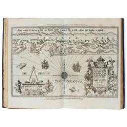
A second and final French edition of this important sea atlas. Two engraved frontispieces, figure with volvelle, full-page figure, 48 double-page charts (one numbered 19.2) and two small maps, all engraved on copper, and 22 profiles engraved in wood, including 4 full-page.
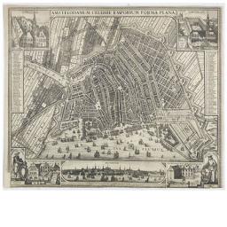
Very rare and decorative plan of Amsterdam with Visscher's imprint. With a panoramic view seen from the IJ and further insets of Council House, The Exchange, House of the Dutch East India Company and House of the West India Company.

A native of Flanders, Gerard van Spaendonck studied under the decorative painter Guillaume-Jacques Herreyns in Antwerp in the 1760s. In 1769, he left for Paris and, having been appointed miniature painter to the newly crowned Louis XVI in 1774, he became a candidate for membership of the Académie Royale the following year, making his Salon début in 1777.
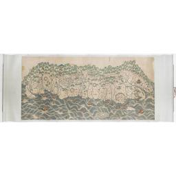
A rare and impressive pictorial Qing Empire map of the western part of Taiwan. Gouache on paper. The map is filled with numerous small pictorial scenes of aboriginals at deer hunting and scenes of daily life. Chinese merchants, voyagers, military scenes, and arriving Chinese junks. Along the top is a red line., the so-called thóo-gû-kau
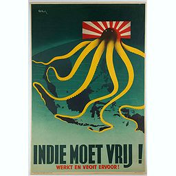
KEELEY, P. - Indie moet vrij vecht ervoor. London, J.Haworth & Brother Ltd, 1944. War propaganda poster by Patrick (Pat) Cokayne Keely, who died in 1970, was a British graphic artist known for his Second World War posters for the Ministry of Information along with stylized commercial posters for publishers, the GPO and public transport.
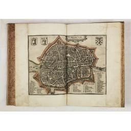
GUICCIARDINI, L. - Descrittione di M. Lodovico Guicciardini patritio Fiorentino, di tutti i Paesi Bassi,… (Antwerp, Plantin, 1581) The book block 23.0 x 31.0 cm. / 9.1 x 12.2 inches. Uncoloured. Folio. In contemp. vellum binding, red mottled edges. A very fine copy.
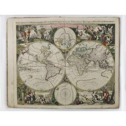
VALK, G. - Nova totius geographica telluris projectio. . . (Amsterdam, ca. 1711) Size of bookblock : 54.0 x 33.0 cm. / 21.3 x 13.0 inches. The maps are in attractive strong original colours. Folio, in contemp. red half-sheepskin binding. Atlas is composed of an allegorical title and 24 double-page maps in fine original coloring.
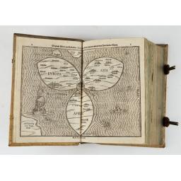
BÜNTING, H. - Itinerarium Sacrae Scripturae. Das ist: Ein Reisebuch,
Uber die gantze heilige Schrifft, in zwey Bücher geteilet... Zuvor
gemehret mit einem Büchlein De monetis et mensuris... Insonderheit aber
mit einer feinen nützlichen Erklerung des Buches Josua... (Magdenburg,
1587).

CHATELAIN, H. - Méthode Pour Etudier La Geographie . . . & un Catalogue des Cartes Geographiques, des Relations, Voyages, & Descriptions les plus necessaires pour la Geographie. Amsterdam: Chez Zacharie Châtelain, 1732 - 1739. 7 volumes. Contemporary full mottled Dutch calf. Spine with seven raised bands, compartments rich gilt with floral patterns, and; boards with large gilt, embossed vignette showing Atlas carrying a sphere surrounded by a Louis XIV floral pattern, and two intricate gilt borders; one with spheres at each corner; gilt dentelles.
![Oranda Fune no zu [= Depiction of a Dutch Ship]. Japan, Kansei 4,](/uploads/cache/28003-256x256.jpg)
Oranda Fune no zu [= Depiction of a Dutch Ship]. Japan, Kansei 4, 2nd month, 9th day, 30 March? 1792. Size: 32.3 x 44.5 inches./ 82 x 113 cm. A very large and extremely detailed Japanese drawing on rice paper of a Dutch ship at the artificial island Deshima, the VOC's outpost in Nagasaki harbor. In the drawing, the ship itself measures about 63 cm from figurehead to stern, giving a scale of about 1:47.
The Japanese texts do not identify the ship but note that it was at Deshima on Meiwa 3, 10th month, 18th day, which is in October or November 1766, probably 21 October.
